Tropical cyclones, hurricanes or typhoons – whatever name one might use, they are all being referred to the same natural hazard which builds up spirally on the water body – depending upon where they occur.
Yet it is different from another spiral disaster, Tornado (also called as Twister) which builds up spirally on the land and is narrower in diameter comparatively. It was not more than a year-long when Tropical Cyclone Nisarga formed over the Western Coast of India. This year the Tropical Cyclone Tauktae has evolved much severe! Many researchers link this severity to one of the impacts of climate change.
But how does the tropical cyclone form?
To bring it down on a simple level, we all know about the water cycle which takes place on huge water bodies like oceans. When the atmospheric pressure of an area of the ocean drops, the wind blows towards that low-pressure area.
Between the tropics, the temperature in the ocean is quite warm enabling the warm moist air to rise up rapidly. As the warm wind moves upwards, the air around it will begin to encircle it spirally. The warm air reaches a height where the air starts condensing to form the clouds. Now the clouds are stacked one above to form the cumulonimbus clouds.
This takes place so rapidly that the clouds and winds being to swirl around the low-pressure area called the eye. When this warm humid air rises through the cumulonimbus clouds, thunderstorms are formed creating the lift. Around the eye is the eyewall, where the high-pressured air from above flows outwards and downwards.
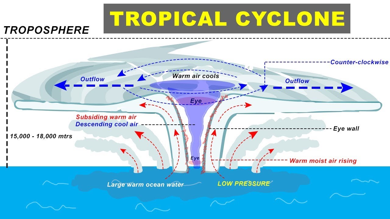
Source: Amit Sengupta, Youtube
The Coriolis Effect of the earth’s rotation causes the outward spin “of clouds and winds” in an anticlockwise direction in the northern hemisphere (and in the clockwise direction in the southern hemisphere). Thus, updrafts continue to fuel the storm with warm, moist air. But, once a storm runs out of updrafts, it starts to weaken. This happens after its landfall or when it passes over cold waters. As a storm begins to slow down, the rain and wind become less intense.
Source: National Geographic
What are the hazards associated with tropical cyclones?
When a tropical cyclone arrives at a coastline, it is potentially fatal and can cause damage to property. This is because tropical cyclones bring with them:
Storm surges – there are huge surges of high water up to 3 meters in height that sweep inland from the sea, flooding low-lying areas.
Strong winds – winds of over 120 km/h (75 mph) blow inland, which are capable of causing significant damage and disruption, for example by tearing off roofs, breaking windows, and damaging communication and transport networks.
Torrential rain and flooding – the warm, humid air associated with a tropical cyclone produce a very large amount of rainfall, often in excess of 200 mm in just a few hours. This can cause short-term flash flooding, as well as slower river flooding as the cyclone moves inland.
When do Hazard turns into a Disaster?
Any hazard becomes a disaster when the impact of disaster is potential damage to humans. So any hazard which affects humans is called a disaster. Depending on the wind speed, the destruction is estimated and the cyclone is categorized. This scale is called Saffir – Simpson Hurricane Windscale. FYI – Earlier the wind speed was measured using Knots.
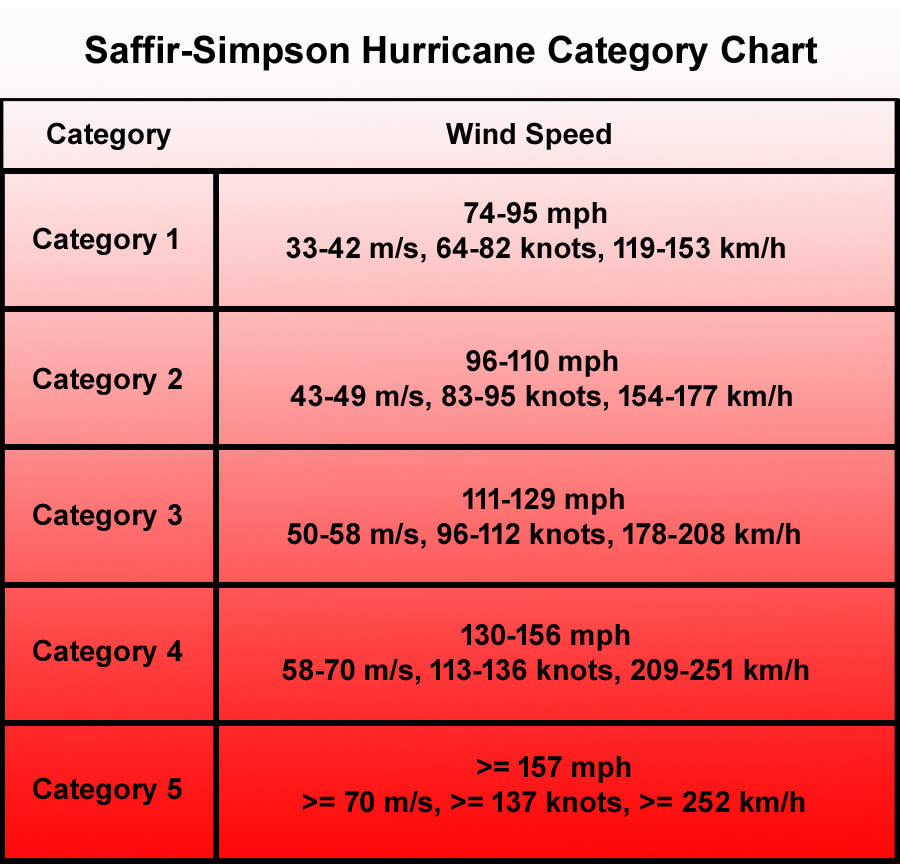
Source: Hurricane Category Chart
How do we name the tropical cyclones?
Nivar, Amphan, Fani, Titli, Bulbul, Gaja… And now Tauktae. As and when a cyclone starts to brew over the Indian Ocean, a couple of common questions come to mind: who names these storms and why a few sound familiar and others not so much?
In 2000, the World Meteorological Organisation (WMO) agreed to start assigning names for cyclones over the North Indian Ocean basin using a list of names suggested by the countries surrounding the ocean basin. Initially, India expressed reservations to naming cyclones and after four years of continuous deliberations, the India Meteorological Department (IMD) initiated the naming of the North Indian Ocean storm with Cyclone Onil in September 2004.
So why can’t we call Tauktae Amphan 2.0 or Amphan 2021 but a new name? Or simply a new name like – Nakshatra or Pareenita!
Out of several criteria for naming cyclones, some very important ones are:
a. names should be politically and culturally neutral,
b. should not be rude and cruel and should be short,
c. easy to pronounce. Although Tauktae is a bit difficult for us as Indians.
d. The maximum permissible length of the cyclone names is eight letters.
e. names should not be gender biased. Good, otherwise people used female names in the past 🙁
f. It should not be repeated. if the hazard turned out to be a disaster!
As per the WMO guidelines, a list of 64 names was drawn in 2004 using the suggested names from eight countries in the region. Exactly a year ago, in May 2020, Cyclone Amphan became the last cyclone to get its name from the old list. (Source: Weather)
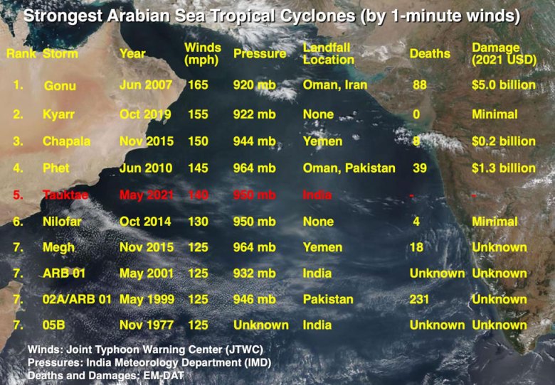
The recent spiral disaster – Tauktae (5th Rank)
Cyclone Tauktae (pronounced as “tau’te”) has been named by meteorologists from Myanmar. The word ‘Tauktae’ means a particular type of gecko or a distinctively vocal lizard, in the Burmese language. Similarly, the previous cyclone that hit the east coast of India, Cyclone Nivar, was named as proposed by Iran.
Traveling through the Arabian Sea in the neighborhood of Kerala, Karnataka, Goa, and Maharashtra, extremely dangerous Tropical Cyclone Tauktae made landfall on the Gujarat coast around 1:30 p.m. EDT (1730 UTC), May 17. In its last advisory just after landfall, at 18 UTC, the Joint Typhoon Warning Center (JTWC) rated Tauktae a major category 3 storm – “extremely severe cyclonic storm” with peak winds of 115 mph (three-minute average) and a central pressure of 950 mb. (Source: IMD)
Source: Yale Climate Connections
As of 21st May 2021, the actual losses are yet to be published but our PM has announced 100 Crore relief for the regions affected by it.
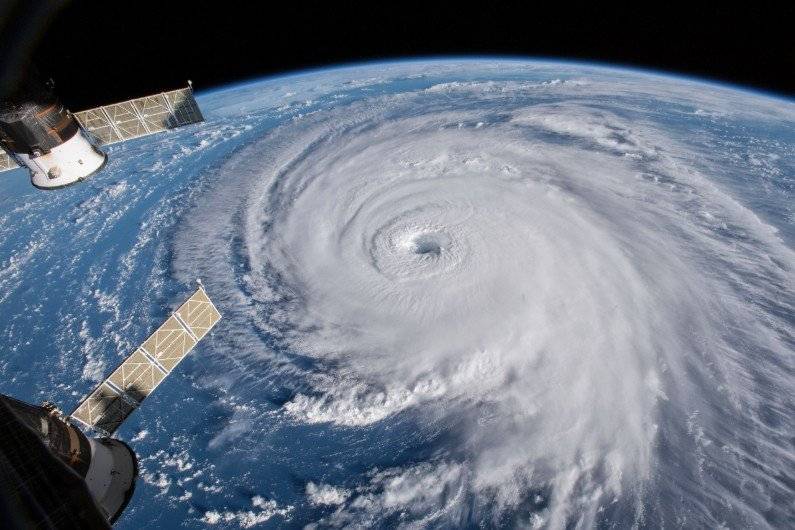
Source: United States Space Force Tweet by Scott Bachmeier
As Cyclone Tauktae dissipated on the Western Coast, Cyclone Yaas prepares to land over the Eastern Coast and is expected to be “Very Severe Cyclonic Storm” with a maximum speed of 130 kmph. For more information on Cyclone Yaas, you can check out Indian Meteorological Department Satellite Images. Remember to Stay Home and Stay Safe !
About the Author – Ms. Farha Nadiadwala
She has done Master’s in Environmental Sciences from Institute of Science, Fort, Mumbai; worked as a researcher with SIES, Navi Mumbai; currently teaching EVM (Environmental Management) course to IGCSE learners from Ira Global School, Dombivali.